top of page

Maps and Aerial Views of Nosara from 1944

  • Writer: E Gutiérrez
    E Gutiérrez
  • Sep 15
  • 1 min read

The community of Nosara is one of the most thoroughly documented in the past century. It holds impressive images and maps that have unveiled secrets and a history full of knowledge for the new generations.


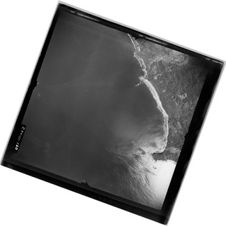
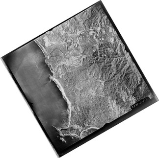
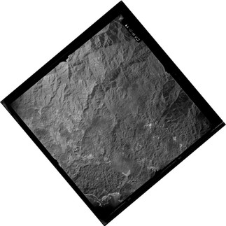
Among these secrets and historical documents is the 1944 map of Nosara, developed by the Costa Rican Geographic Institute. This map was created thanks to aerial photographs taken by the United States Air Force, which reveal the reality of the topography and the natural, human, and historical elements of that time. On the map, one can see the course of the Nosara River, the first houses around Nosara’s central plaza, the old trails connecting to the coast, the well-known Baltodano Hacienda with its first buildings, the airstrip at Playa Nosara, the names of rivers and streams, as well as the old cemetery that still exists in Playa Guiones. The houses can be observed and counted as small black squares in each village.


These maps were recovered from the National Archives and are being published for the study, enjoyment, and memory of the Nosara community.


Instituto Geográfico de Costa Rica. Mapa topográfico de Nosara. Litografía, 62.5 × 53.5 cm. Escala 1:25 000. Preparado a partir de fotografías aéreas de 1945. San José: Instituto Geográfico de Costa Rica, 1957. Archivo Nacional de Costa Rica. Versión alta resolución: https://drive.google.com/drive/folders/11DPb2G9u-BCj0aIAkdGP9nmUol_3lxSr?usp=sharing

Instituto Geográfico de Costa Rica. Punta Guiones, provincia Guanacaste. Hoja Nº 3045 ISW. Copia en papel. Preparado a partir de fotografías aéreas de 1945. San José: Instituto Geográfico de Costa Rica, 1957. Archivo Nacional de Costa Rica. High Resolution: https://drive.google.com/drive/folders/11DPb2G9u-BCj0aIAkdGP9nmUol_3lxSr?usp=sharing

Photographs taken by the United States Air Force for the National Geographic Institute


Comments


bottom of page